This is the nearest location Skew-T plot to Eau Claire. This graph shows instability in the atmosphere. The parcel lapse rate (solid yellow line) is above the dew point and the temperature. Since the Lifted Index is positive, this, in contrast with the parcel lapse rate, says that the atmosphere is stable. The K Index is 18, which is in the small convective potential range. With all these factors taken in we had a rather small chance for severe weather, but it being the weekend we got a small thunder storm.
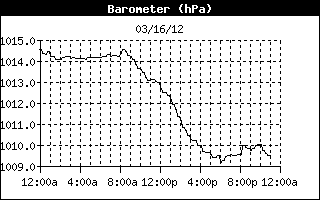
If this picture did not turn out as I wanted it to, it shows that at 8am, the pressure steadily fell until 5pm, where the pressure went up a little more before falling again. At 8pm is when we had our mini storm. I was sitting in my room when I started to hear thunder then we were rained on for a very short while. As show by...
...this graph!
Also on a side note I'm going to guess we had very little if any cloud cover last night, because clouds would hold in the heat radiating off the earth the graph below shows a very steep increase in temperature from the morning to later afternoon.


No comments:
Post a Comment